Diplomatic sources expect the Lebanese to return to indirect negotiations with Israel, under American pressure, after the American administration becomes ready for that. That is, after completing appointments in the the Ministry of Foreign Affairs posts in particular. Negotiation has become easier than ever, after the maritime area which Lebanon clings to has been put aside. Despite internal demands that an inch of Lebanon’s maritime rights should not be abandoned. Is the amendment of the decree right or not? And what do the strategists think about putting this issue aside?
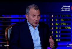
Strategic expert, Dr. Nabil Khalifa, explained to “Voice of Beirut International,” that what is happening in Lebanon in terms of talking about maritime borders is for entertainment. I explained the Works Committee in the House of Representatives in 2013, the 2007 big mistake with Cyprus. The maritime border is to the south point 61, and what was the basis of saying that it was in point 23. I have an international map based on the law of the sea and not from specific companies. My work is based on Geopolitical Atlas of Maritime Areas and the Law of the Sea. And the story is not about few more or less kilometers, the topic was presented scientifically and objectively. Lebanon agreed to the International Law of the Sea, and signed it in 1995. As for Israel, Syria, Turkey, Iran, and the United States of America, they did not sign this law. And now the number of signatory states has reached 131, in order for it to be issued under the banner of the United Nations, so that the majority of states must sign it. Any increase which is not based on clear aspects will be “ humiliating”
And he said, in the book he adopted to define the international maritime borders, including the borders of Lebanon, that Lebanon’s maritime borders extend to more than 865 km. And the 23rd point is not correct. Our boundary line must start from Ras Naqoura to the number 61% of the midfield. As for Israel, it is 39% of this midfield. Lebanon’s seafront is longer than Israel’s seafront. The length of the Lebanese sea front is 188.5 km, while the length of Israeli one is 120.5 km. The length of the two façades together is 309 km. Lebanon has 865 km, which is hoff line, and this is the issue. Determining the correct boundaries requires coordinates.
He pointed out that Israel does not believe in Ras al-Naqoura as the starting point for the maritime borders. But the entire area or range from point 61 to the midfield of Ras Naqoura is for Lebanon. And among that the 865 km, meaning the Hoff line, which is 35 percent of Lebanon, and the rest of the area is a buffer zone that Israel can use and withdraw oil from. That is, 865 km, of which 535 are for Lebanon, and 330 remain a buffer zone between the two countries, which means that Lebanon and Israel can use them, according to Hove.


 Sueraya Shaheen